Tag: Off-Road

La Sal Pass

La Sal Pass is a trail of moderate difficulty on the western portion and easy difficulty on the eastern side of the plateau. To pass through the western side of the pass you’ll need a 4×4 truck with good tires and ground clearance while the eastern slope is minivan friendly under dry conditions. There is no single hard obstacle, just lots of small shelf sections, a talus rock slope, boulders strewn about, and a few fallen trees that may get in your way. Be ready to deal with oncoming traffic on narrow sections of the trail and possibly back up in an undesirable location. Don’t go on this trail if you’re scared of heights.

The base of the trail starts at about 4,000 feet and climbs to ~10,400 feet at the highest point and will require several hours to traverse. The nearest paved road on the western edge is Pack Creek Road and for the eastern face is UT-46. My only regret on this trail is not starting it a few hours earlier in the day. You’ll find lots of trail information and photos below and the rest of the amazing photos may be found on the full page. Enjoy!

U.S. Forest Service Manti-La Sal Forest – Maps and Publications

U.S. Forest Service Manti-La Sal Forest – Road/Trail/Campground Conditions, Moab Monticello District


Miscellaneous Truck updates

It’s been a while since I’ve posted some progress updates on the truck build so here it goes. The following is a short list of components I’ve changed out and a few maintenance items performed:

I had approximately four quarts of automatic transmission fluid changed out and did an oil change with fine lab results.

I replaced one Blue Sea Systems fuse block with the higher capacity Safety Hub 150. The Safety Hub 150 is rated for up to 280A and allows the use of higher current/interrupt rated MIDI®/AMI® fuses in addition to smaller ATO/ATC fuses. I also finally got around to covering up the exposed “hot” points on the isolation breaker, upgraded a few ground wires and replaced the Odyssey Group 34R battery with a NorthStar 27F battery.

After giving the exhaust a few love taps on a trail recently I had a new pipe welded onto the end of the muffler. There’s so much more clearance this way…

This slideshow requires JavaScript.

I replaced the Rigid LED flood lights with a Vision X Light Cannon. This light is simply amazing!

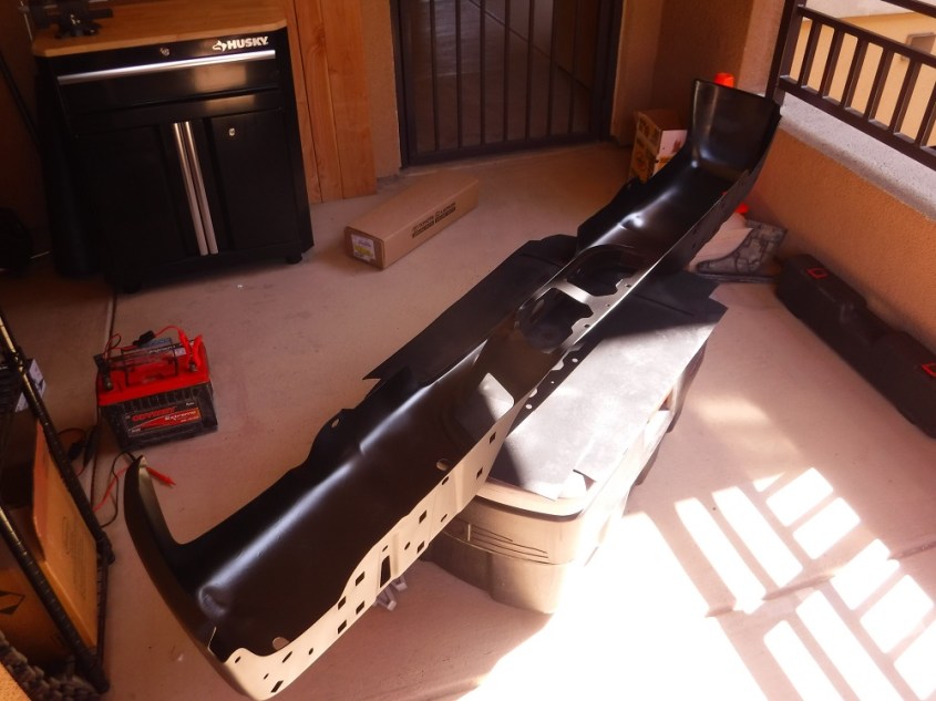
After putting enough dents into the rear bumper is was time to get a new-to-me bumper off of craigslist for $80 and replace the disgusting chrome with some satin black spray paint.

DSCF6310

Those are all of the updates for now, what’s your favorite truck mod?

Hell’s Revenge

Hell’s Revenge is a difficult trail in the Sand Flats Recreation Area near Moab, UT. A truck that passes through this trail should have 33″ tires, one locker, some skid plates, and good suspension articulation. Some of the hardest obstacles have bypasses or may be avoided but you should be prepared for a hardcore trail (especially if it has just rained).  I opted not to drive my truck on this trail and went for a long hike. It’s a nice perspective and I wanted to walk a little of my 4,000 mile road trip. Enjoy the photos and find the rest of them on the dedicated page!

Trail Location:

hell_revenge_0

Fins & Things

Fins and Things is a difficult trail in the beautiful area around Moab, UT that everyone should pass through once in their life. This area is very visually amazing and stunning! My dash camera decided to stop properly working shortly before arriving in the area so I only drove through the western portions of the trail. After that I just took some photos and videos of other drivers surmounting some of the obstacles. A truck with 4×4, good ground clearance, and decent tires should be able to make it through this trail. Be ready to scrape your trailer hitch and get used to having a fun time seeing over the hood of your truck if you drive a full-size. A day-trip pass for the Sand Flats Recreation Area is $5. Enjoy the photos and be sure to look for the rest of them on the dedicated trail page!

Trail Location:

fins_location

Culp Valley Road

Culp Valley Road is an easy trail with no significant obstacles to note that any truck with some ground clearance should be able to pass through. The western end of this trail starts in Ranchita at Old Wilson Valley Road and heads east where it ends at S-22. This road passes through the transition zone between the mountains (~4000 ft) and desert floor near Borrego Springs. According to Google Maps this road doesn’t exist but if you’re going out to this area you should really have some good maps (if you’re frugal like me) or a SD card loaded up with some trail data for your Lowrance GPS unit (if you’re a big spender). The eastern edge of this trail passes through the Paroli Homestead (of which not much remains), a long abandoned ranch that a family was able to eek out a survival on for a few years. Enjoy the photos and videos and look for the rest of them here on the dedicated page!

Western starting location

culp_west

Culp Valley Cultural Preserve (PDF)

A Cahuilla Village in the Boulders of an Upland Valley


Cedar Creek Road

Cedar Creek Road is a trail of easy difficulty that a 2WD truck with some ground clearance should easily pass through in dry conditions. There are no hard obstacles on this trail, just wonderful views of the canyon and an easy-going drive that is close to San Diego with little risk of vehicle damage. There are also numerous hiking trails in the area for when you just need a nice, long walk outside. This trail is very picture heavy so be sure to enjoy all of the photos here on the dedicated page!

This is where the southern end of the trail starts, even though it does not show up on Google Maps. Cedar Creek Road heads north from the junction at Three Sisters Falls trailhead.

cedar_start

White Mountain

White Mountain is a trail of moderate difficulty that a 4×4 truck with decent tires should be able to navigate. No obstacle is terribly difficult but there are lots of tough rocks of which a few demand careful tire placement. For much of the trail the brush is very tight or there is a steep cliff to one (or both sides) which may make it very fun to deal with opposing traffic. It would be wise to stop your vehicle at an open spot when you get a chance and take a quick look to see if any other trucks are heading your way. For this trip I was a passenger (for once) and just got to enjoy the scenery a little more than I usually do. I also had a great chance to take more photos than normal, enjoy the rest of the photos and videos here on the complete page!

White Mountain location:

white_mountain

Espinosa Trail

The Espinosa Trail is a path of moderate difficulty that will be hard on your truck’s paint job and is harder yet on full-size trucks. No single obstacle really stands out, just lots of moderately sized rocks and hinderances that are more difficult in wide and long vehicles. The Espinosa Trail is located in the Corral Canyon OHV area approximately 50 miles east of San Diego and is conveniently located just south of I-8. For those who are more adventurous and have capable rigs there are the two difficult trails known as Bronco Peak and Sidewinder for your enjoyment. Enough of my written description of this wonderful trail though, enjoy the photos and videos and find all of them here on the full page!

stelprdb5277239


The Coxey Trail (3N14)

The Coxey Trail (3N14) is a trail of easy difficulty north of Big Bear Lake that any truck with some ground clearance would easily drive through. This trail starts high near Big Bear Lake and gently descends down the San Bernardino Mountains into the vast expanse of the Mojave Desert. The southern end of the trail starts in Fawnskin along CA-38 at the Rim of the World Drive. The northern end of the trail is at the junction of Bowen Ranch Road and Coxey Road. This is a fun, relaxing trail run that will be well worth your time. The rest of the photos and videos may be found here on the dedicated page. Enjoy!

Clark’s Summit and Skyline Drive

I’m putting both of these trails on the same page due to how they intertwine with each other. I suppose you could just drive along Skyline Drive on its own but only completing Clark’s Grade would require a U-turn as soon as you reached the top. A 4×4 truck with decent ground clearance and tires will easily pass through this road under dry conditions. The path to Clark’s Summit is a narrow shelf road in which encountering opposing traffic is rather miserable. I’ve generally completed this route from the southern end starting at Seven Oaks Road just north of CA-38.

Upon reaching Clark’s Summit Skyline Drive goes off both east and west and snakes its way north towards a few different spots in Big Bear Lake. The views the entire way are amazing and well worth your time! There are many hiking and biking trails that pass through Skyline Drive so be sure to watch out for pedestrians. There are multiple methods of reaching both of these trails and I will have to pass through more of them in the future. Be sure to look on the dedicated page to find all of the photos and videos and enjoy!